
To set base properties of map, use Map Properties command.
You have following possibility to launch Map Properties command:
- From Map drop down menu select Map Properties…
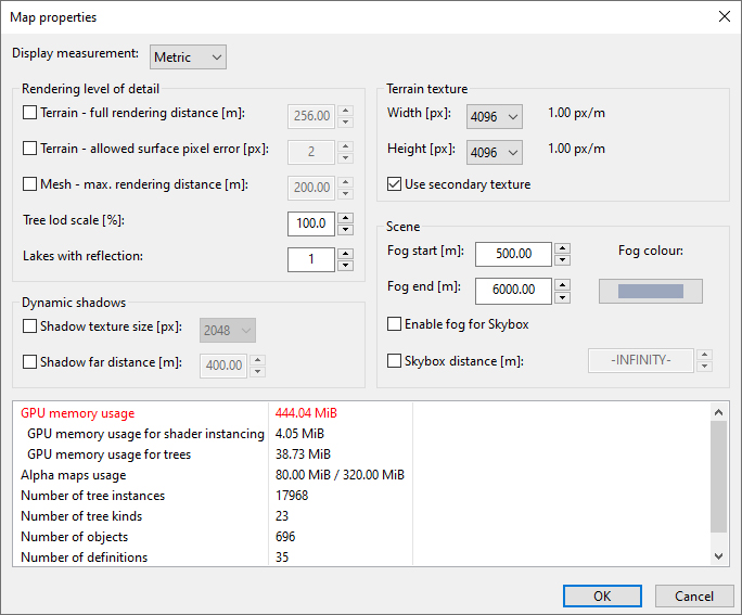
Display Measurement switches display units between Metric = meter / Imperial = yard
Rendering level of detail
Tree lod scale (10-100%) allows shorten the distance where trees are changed from 3D to billboard representation. This can be used for the maps which have too many trees and this causes performance problems. Default value is 100% (300m) and is defined in configuration file.
Lakes with reflection sets number of lakes near to camera rendered with correct reflection – in correct height. If there are more lakes in the map with water in different absolute heights, reflection for each of them must be calculated extra, what significantly drops performance of map. So, default value is 1 – only one lake near to camera is correctly calculated. All other lakes have reflection calculated from the plane defined by this to camera nearest lake. If camera moves closer to another lake, the calculation is switched according to the water plane of this lake. If you have good hardware you can higher the number of simultaneously calculated lake reflections. Not all lakes must have reflection. If you think a lake is not very important (small or behind of trees…) or should be muddy, you can switch off reflections for this lake also by Lake Properties. Lakes without reflections have very low performance requirements.
Terrain – full rendering distance [m] set distance until full rendering with full shaders is used. After it used simple rendering with using terrain texture. Smaller distance provides better performance but less visual quality. This option is provided as override for SimpleRenderingDist setting in globals.conf. If check box is not check then value from globals.conf is showed but previously set value is remembered. On check previously saved value is showed.
Terrain – allowed surface pixel error [px] defined how big pixel deference is allowed if changing surface geometry to lower level. Bigger pixel error provides better performance but changing of level of details is more visible. It is override for PixelError in globals.conf.
Mesh max rendering distance [m]/unit size define distance where object of unit size (for example 1 meter) can be hidden. This distance is multiplied by object size so if it is set for example to 200 meters, 0.5 meter big object can be hidden after 100 meters, and 10 meters big after 2000 meters. Smaller distance provides better performance but makes objects hiding more visible. It is override of MeshMaxRenderingDistance in globals.conf.
Dynamic shadows
Shadow texture size [px] Smaller shadow texture provides better performance but shadows are blurred and squared. It is override of ShadowTextureSize in globals.conf.
Shadow far distance [m] define how distanced object from camera should be included in dynamic shadows. Smaller distance provides better performance and sharper shadows, but showing and hiding shadows is more visible. It is override of ShadowFarDistance in globals.conf.
Fog and Background
Fog start [m] set distance where fog start
For end [m] set distance where fog end
Fog color set which color fog has.
Note:
Fog is linear interpolated between these boundaries.
Distance to Background [m] can be useful for mountainous maps. Default value infinity means that if camera is moving up or down background is always in one size according to camera eye. With lower value of this property the background is going down if camera is elevated up.
Enable fog for Background is usable in case that background size is not infinity, ideally with size of terrain. Then fog on terrain can smoothly continue on background.
Terrain
Terrain texture size. Terrain texture is texture used for rendering far off terrain. Bigger terrain texture provides better quality for far terrain. Common value is 4096×4096. Bigger 8192×8192 is usable only for better computers (1GB GPU RAM, 4GB RAM and Windows 64bit). Setting is used in update map command.
Use secondary terrain texture is used by default for terrain bigger than 4096 meters, but it is optional here. It uses the same size as terrain texture and use area which is defined for light map. Using secondary terrain texture provide better quality of far terrain.
The bottom part of the Map Properties dialog is used to show the map Performance values.