
To finalize the edited map, use Update Map command.
You have following possibility to launch Update Map command:
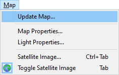
- From Map drop down menu select Update Map…
Note:
Some operations like update of static shadows, update of textures, generating of sticks … require more time and therefore are not performed after each particular change (for example after modeling of terrain, moving of object, editing of material curves …). These operations which require more time are concentrated in the Update Map command and user decides when to run it not to hold fluent using of other commands.
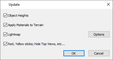
Object Heights
Activate this checkbox in case that objects do not follow a new terrain height after Import Surface or other commands.
Apply Materials to Terrain
Activate this checkbox after one or more material curve(s) have been created, edited or removed and after modification of textures or materials in library or via texture manager. You can also update the terrain textures after any change by using the Texture Manager command. This operation can take longer time (e.g. 15 minutes) in case many curves are drawn in the map and this is the first run of Update Map command. The processed and unchanged material curves are copied to the cache file so next run of Update Map is faster.
Lightmap
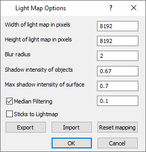
Update of lightmap is needed to update static shadows after terrain modification, or inserting, moving or removal of objects in the map. The Options dialog allows to change the default shadows intensity or resolution of the lightmap picture. Allows also manual editing of lightmap out of editor if necessary.
Red, Yellow sticks; Hole Top Views, etc…
Use this option after terrain modification, creation / editing or removal of a material curve (water) or any other change in the map, which may affect hole top views and stick positions.
This option updates:
- positions of yellow, red sticks which are generated along the Water / Flowing Water material curves. Generating of sticks can be allowed/suppressed in the Material Curve dialog.
- positions of white sticks, which are automatically generated along the Outer or Inner Boundary curves. Generating of sticks can be allowed/suppressed via context menu on the Outer or Inner Boundary curve.
- top view preview pictures which are generated for the Course Viewer usage
- terrain texture which is used for distance terrain blocks instead of slower methods used for the close blocks. The terrain texture is in 4096 x 4096 resolution by default. For faster work editor supports also
Note:
Watch status line to see whether the terrain texture is compressed on GPU or CPU. As default it should run on GPU for Nvidia graphics cards. On CPU it runs considerably slower. In case that the compression of terrain texture runs on CPU, update your graphics card driver.